 Sisilia Frederika
The logistical success of a crewed mission to Mars hinges not on what astronauts bring from Earth, but on what they can harvest upon arrival. In the field of planetary science, this concept is known as In Situ Resource Utilization (ISRU), and it represents the fundamental divide between a viable long-term exploration strategy and a prohibitively expensive short-term endeavor. Central to this strategy is the location of accessible water ice. Subsurface ice is more than a source of hydration for astronauts; it is the raw material required to generate breathable oxygen and, more critically, the hydrogen and oxygen needed to manufacture rocket propellant for the return journey. By producing fuel on the Martian surface, the initial launch mass of a mission from Earth can be reduced by hundreds of metric tons, drastically lowering costs and technical complexity.
However, identifying the ideal landing site requires solving a complex geographical puzzle. While Mars is known to possess vast quantities of water ice, its distribution is far from convenient for human habitation. The bulk of the planet’s ice is sequestered at the poles, regions where the Sun remains low on the horizon for much of the year. For a crewed mission dependent on solar power, the polar regions are functionally off-limits. Conversely, the equatorial regions offer abundant sunlight and more temperate conditions, but the thin Martian atmosphere—roughly 1% of Earth’s surface pressure—causes ice in these regions to sublimate. In the low-pressure environment of the equator, ice does not melt into liquid; it transitions directly from a solid to a gas and vanishes into the atmosphere. This leaves the mid-latitudes as the "Goldilocks" zone for future explorers: far enough from the poles to provide adequate solar energy, yet far enough from the equator to potentially harbor buried ice sheets.
The Evolution of Martian Water Detection
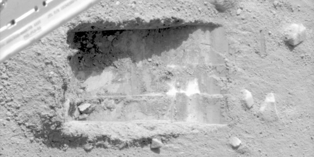
The search for Martian water has evolved significantly over the past two decades. In June 2008, NASA’s Phoenix lander provided the first direct evidence of subsurface ice at high latitudes. While excavating a trench nicknamed "Dodo-Goldilocks," the lander’s robotic arm exposed bright white chunks of material. Over the course of several days, cameras filmed these lumps as they slowly disappeared—a clear indication of water ice sublimating after being exposed to the atmosphere. This discovery confirmed that ice existed just inches below the Martian regolith (soil), but it also highlighted the fragility of these deposits.
Following the success of Phoenix, orbital observations became the primary tool for mapping the planet’s hidden resources. Two key missions, the Mars Global Surveyor (MGS) and the Mars Reconnaissance Orbiter (MRO), have spent years collecting data on the planet’s surface characteristics. These orbiters utilize thermal emission spectrometers and imaging systems to monitor how the ground heats up during the day and cools down at night. This property, known as thermal inertia, is the cornerstone of the Subsurface Water Ice Mapping (SWIM) project. Because ice-rich ground retains and releases heat differently than dry sand or solid rock, scientists can use thermal rhythms to infer what lies beneath the surface without ever touching the ground.
New Research: Harmonizing Disparate Data Sets
Despite years of orbital data, maps of the Martian mid-latitudes have remained notoriously inconsistent. To address these discrepancies, two new papers published in the Planetary Science Journal have introduced more rigorous methods for identifying ice deposits. These studies, led by researchers Hanna Sizemore and Samuel Courville of the Planetary Science Institute (PSI), represent a shift from speculative mapping to engineering-grade data analysis.
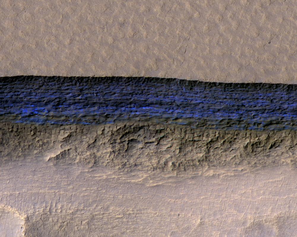
Hanna Sizemore’s research focuses on the concept of "consensus mapping." Historically, different instruments and modeling techniques have produced varying results for the same geographical coordinates. Factors such as atmospheric dust, seasonal frost, and surface roughness can "noise" the data, leading to false positives or missed deposits. Sizemore’s team compared three independently produced maps of the Martian subsurface, identifying areas where the data sets reached a consensus.
According to the study, broad agreement between different instruments—such as thermal sounders and ground-penetrating radar—increases the reliability of a potential landing site. Conversely, areas where the maps disagree are identified as high-uncertainty zones. While these regions of disagreement are of great interest to robotic explorers seeking to understand Martian geology, they are categorized as high-risk for human missions. Sizemore’s work provides a framework for mission planners to exclude "untrustworthy" terrain, narrowing the search to locations with the highest empirical support.
From Qualitative Science to Quantitative Probability
While Sizemore’s work identifies where scientists agree, Samuel Courville’s research focuses on quantifying that certainty into a language that engineers can use: probability. In the context of a multi-billion dollar mission, a statement like "we think there is ice here" is insufficient. Mission planners require statistical confidence intervals to justify the landing of a multi-ton spacecraft.
Courville’s paper converts diverse data points into a singular probabilistic value. By analyzing the frequency and consistency of ice detection across various methodologies, the study can assign a percentage-based likelihood to specific coordinates. For example, a location where two distinct techniques suggest ice and one does not might be assigned a 64 percent probability of success. This shift from qualitative observation to quantitative risk assessment allows for a more "actuarial" approach to mission planning. If a mission requires a 90 percent certainty of water access to guarantee a return flight, planners can now use these maps to identify the few specific patches of Mars that meet that threshold.
The "One-to-Five Meter" Gap
Despite these advancements, a significant technological hurdle remains. Current orbital instruments are highly effective at reading the top meter of the Martian soil using thermal signatures. At the other end of the spectrum, lower-frequency orbital radar can penetrate the ground to depths of five meters or more, identifying massive glaciers buried under layers of debris.
However, the "sweet spot" for human exploration—the range between one and five meters deep—remains a blind spot. This is the depth at which ice is most likely to be protected from sublimation while still being accessible to the type of excavation equipment a crew could realistically bring to Mars. Digging deeper than five meters requires heavy industrial machinery that is currently too massive to transport, while ice found at less than one meter is often patchy and susceptible to seasonal changes.
Bridging this gap requires a new generation of high-frequency orbital radar. Currently, no such instrument is in operation around Mars. Until a dedicated mission, such as the proposed International Mars Ice Mapper (MIM), is launched to specifically probe these intermediate depths, the maps produced by the SWIM project represent the most sophisticated resource available to the scientific community.
Strategic Implications for the 2030s and Beyond
The implications of this research extend far beyond academic curiosity. As NASA and its international partners look toward the 2030s and 2040s for the first human footprints on the Red Planet, the "Water Map" will dictate the location of the first Martian base.
The presence of water ice influences every aspect of mission architecture. If ice is easily accessible, the mission can utilize the Sabatier reaction—combining Martian atmospheric carbon dioxide with hydrogen derived from water ice to produce methane (CH4) and oxygen (O2). This chemical process is a well-understood pillar of aerospace engineering, but it requires a steady supply of H2O. Without it, every liter of propellant must be hauled from Earth, creating a "tyranny of the rocket equation" where more fuel is needed just to carry the fuel, eventually reaching a point of diminishing returns that makes long-stay missions impossible.
Furthermore, the identification of these ice-rich mid-latitude sites provides a roadmap for upcoming robotic precursor missions. Before humans are sent, smaller rovers or stationary landers equipped with specialized drills will likely be dispatched to the high-probability sites identified by Sizemore and Courville to "ground-truth" the orbital data.
In summary, while the geography of Mars presents significant challenges, the refinement of subsurface mapping is bringing the goal of human exploration closer to reality. By synthesizing years of thermal data into probabilistic maps, researchers are providing the foundational data necessary to turn the Martian regolith into a refueling station for the next great leap in human history. The "Goldilocks" zones of the mid-latitudes are no longer just points on a map; they are the potential cradles of the first human civilization on another world.