 George Chandra Eka
MapQuest, the veteran mapping service, has unveiled a significant new feature, integrating a comprehensive layer into its mobile application that displays the locations of known outdoor surveillance cameras and automated license plate readers (LPRs). This development marks another notable stride in the company’s unexpected resurgence, providing users with a new dimension of awareness regarding public monitoring infrastructure. The update allows individuals to toggle a map layer revealing the precise placements of various surveillance technologies, including those from prominent providers like Flock Safety, Motorola Solutions (Vigilant), Genetec, Axis Communications, Axon, Leonardo (ELSAG), Neology, Rekor, PlateSmart, Ubicquia, and Verkada. Positioned alongside existing options for viewing traffic and incident reports, this feature is readily accessible, underscoring MapQuest’s commitment to enhancing user information and transparency in an increasingly surveilled environment.
MapQuest’s Unexpected Resurgence and Strategic Pivots
The integration of surveillance camera locations is the latest in a series of strategic moves that have seen MapQuest re-enter the public consciousness and gain renewed traction in the highly competitive digital mapping landscape. For years, MapQuest, once a pioneering force in online navigation, had largely been overshadowed by tech giants like Google Maps and Apple Maps. However, the past several months have witnessed a remarkable turnaround, characterized by a blend of principled stances and practical feature enhancements.
A pivotal moment in MapQuest’s recent resurgence occurred when it publicly refused to rename Lake Ontario to "Lake America" in its application. This stood in stark contrast to both Google Maps and Apple Maps, which, for a period, had erroneously displayed the altered name for U.S. users. MapQuest’s decision to uphold geographical accuracy and resist a politically charged, incorrect alteration garnered widespread praise and media attention, positioning the company as a reliable and principled alternative to its larger rivals. This episode resonated with a segment of users disillusioned by the perceived algorithmic malleability of other platforms.
Building on this momentum, MapQuest has also focused on improving its core utility, addressing long-standing feature gaps. The addition of Android Auto support significantly expanded its reach, allowing users to seamlessly integrate MapQuest navigation into their vehicle’s infotainment systems. This move was critical for a mapping service aiming to compete in an ecosystem where in-car navigation is increasingly paramount. Furthermore, the introduction of public transit directions, while seemingly a foundational feature for modern mapping applications, marked a crucial step in MapQuest’s efforts to cater to a broader user base that relies on diverse modes of transportation. These updates collectively signaled a revitalized commitment to functionality and user experience, laying the groundwork for more innovative features like the new surveillance camera layer.
The Proliferation of Surveillance Technology in Public Spaces
The context for MapQuest’s new feature is the exponential growth and widespread deployment of surveillance technologies, particularly automated license plate readers (LPRs) and networked camera systems, across communities globally. These systems, once primarily confined to high-security areas or major thoroughfares, are now a common sight in residential neighborhoods, commercial districts, and public gathering spaces.
Understanding License Plate Readers (LPRs) and Flock Cameras
At the forefront of this expansion are systems like those offered by Flock Safety. Flock cameras are specialized LPR devices designed to capture images of vehicles and their license plates, often recording additional details such as vehicle make, model, and color. These cameras are typically deployed by law enforcement agencies, homeowners’ associations (HOAs), and businesses, marketed primarily as tools for crime prevention and solving. They operate by continuously scanning plates, comparing them against "hot lists" of vehicles associated with Amber Alerts, stolen cars, or wanted individuals. The data collected by Flock cameras is stored in a cloud-based network, often accessible to a wide array of law enforcement partners, facilitating rapid information sharing across jurisdictions.
Beyond Flock Safety, the surveillance landscape is populated by numerous other significant players:
- Motorola Solutions (Vigilant): A major provider of public safety and enterprise security solutions, Vigilant Solutions (now part of Motorola) offers extensive LPR networks and data fusion centers that integrate LPR data with other law enforcement intelligence.
- Genetec: Known for its unified security platforms, Genetec provides video surveillance, access control, and LPR solutions that allow for comprehensive monitoring and data management.
- Axis Communications: A global leader in network video, Axis provides a wide range of IP cameras and video encoders used in various surveillance applications, from city-wide monitoring to commercial security.
- Axon: Predominantly known for its body cameras and Taser devices for law enforcement, Axon also offers comprehensive digital evidence management systems that can integrate with fixed surveillance cameras and LPR data.
- Leonardo (ELSAG): ELSAG is a key player in the LPR market, providing high-speed, accurate LPR systems used by police departments for vehicle identification and tracking.
- Neology: Specializes in secure identification and payment solutions, including advanced LPR technology used for tolling, intelligent transportation systems, and law enforcement.
- Rekor: Focuses on intelligent roadway systems and LPR technology, offering real-time vehicle recognition and data analytics for traffic management and public safety.
- PlateSmart: A pioneer in software-only LPR solutions, PlateSmart provides analytics and intelligence platforms that can be integrated with various camera systems.
- Ubicquia: Known for smart city solutions, Ubicquia offers compact surveillance and sensing platforms that integrate into existing streetlights, enabling widespread deployment without significant new infrastructure.
- Verkada: Provides enterprise video security and access control systems known for their cloud-managed, user-friendly interface, increasingly adopted by schools and businesses.
The presence of these diverse technologies, often operating in interconnected networks, highlights the pervasive nature of modern surveillance. Their deployment is often justified by claims of increased public safety, reduced crime rates, and enhanced efficiency in law enforcement operations.
The Data Landscape: Collection, Storage, and Sharing
The widespread deployment of LPRs and surveillance cameras generates an enormous volume of data, raising significant questions about collection protocols, storage mechanisms, and sharing practices. Each camera, whether part of a municipal network or a private HOA system, is continuously capturing images and, in the case of LPRs, extracting alphanumeric data from license plates.
What Information is Gathered?
LPRs primarily capture license plate numbers, along with a timestamp, location coordinates, and an image of the vehicle and its immediate surroundings. This image often includes details such as the vehicle’s make, model, color, and even unique identifiers like bumper stickers or dents. While the explicit intention is to track vehicles, the contextual imagery can inadvertently capture individuals, revealing their presence at specific times and locations. Some advanced systems can also infer patterns of movement, direction of travel, and even speed.
Interoperability and Data Sharing Networks
A critical aspect of the surveillance ecosystem is the interoperability and data-sharing capabilities among various entities. Data collected by a Flock camera in one neighborhood, for instance, can be made accessible to law enforcement agencies across a city, county, or even state lines. Companies like Vigilant Solutions operate massive databases that aggregate LPR data from numerous sources, creating vast searchable repositories of vehicle movements. This data can be queried by authorized personnel to track a vehicle’s historical movements, identify its typical routes, or ascertain its presence at a crime scene. These networks facilitate rapid information exchange, potentially aiding in investigations but also creating a comprehensive digital trail of individuals’ movements, regardless of their involvement in any wrongdoing.
Retention Policies and Accessibility
Data retention policies vary significantly by jurisdiction and by the specific vendor. Some systems may retain data for only a few days or weeks, while others might store it for years. The sheer volume of data necessitates robust cloud storage solutions, often managed by the surveillance technology providers themselves. Access to this data is typically restricted to law enforcement and security personnel, but the scope of "authorized personnel" can be broad, and audit mechanisms to prevent misuse are not always transparent or rigorously enforced. Concerns have been raised about the potential for unauthorized access, data breaches, and the use of this information for purposes beyond its initial justification, such as civil enforcement or even commercial exploitation.
Navigating Privacy Concerns and Public Debate
The extensive deployment of surveillance cameras and LPRs has ignited a fervent public debate centered on the fundamental tension between public safety and individual privacy rights. While proponents argue that these technologies are indispensable tools for deterring crime, apprehending criminals, and enhancing overall security, civil liberties advocates express profound concerns about the erosion of privacy and the potential for abuse.
Civil Liberties vs. Public Safety
The core of the debate lies in balancing the collective good of a secure society against the individual right to move freely without constant government or corporate monitoring. Law enforcement agencies often present compelling statistics linking surveillance camera deployment to reductions in specific types of crime or increases in apprehension rates for stolen vehicles. They emphasize the critical role these technologies play in solving complex cases and ensuring community safety.
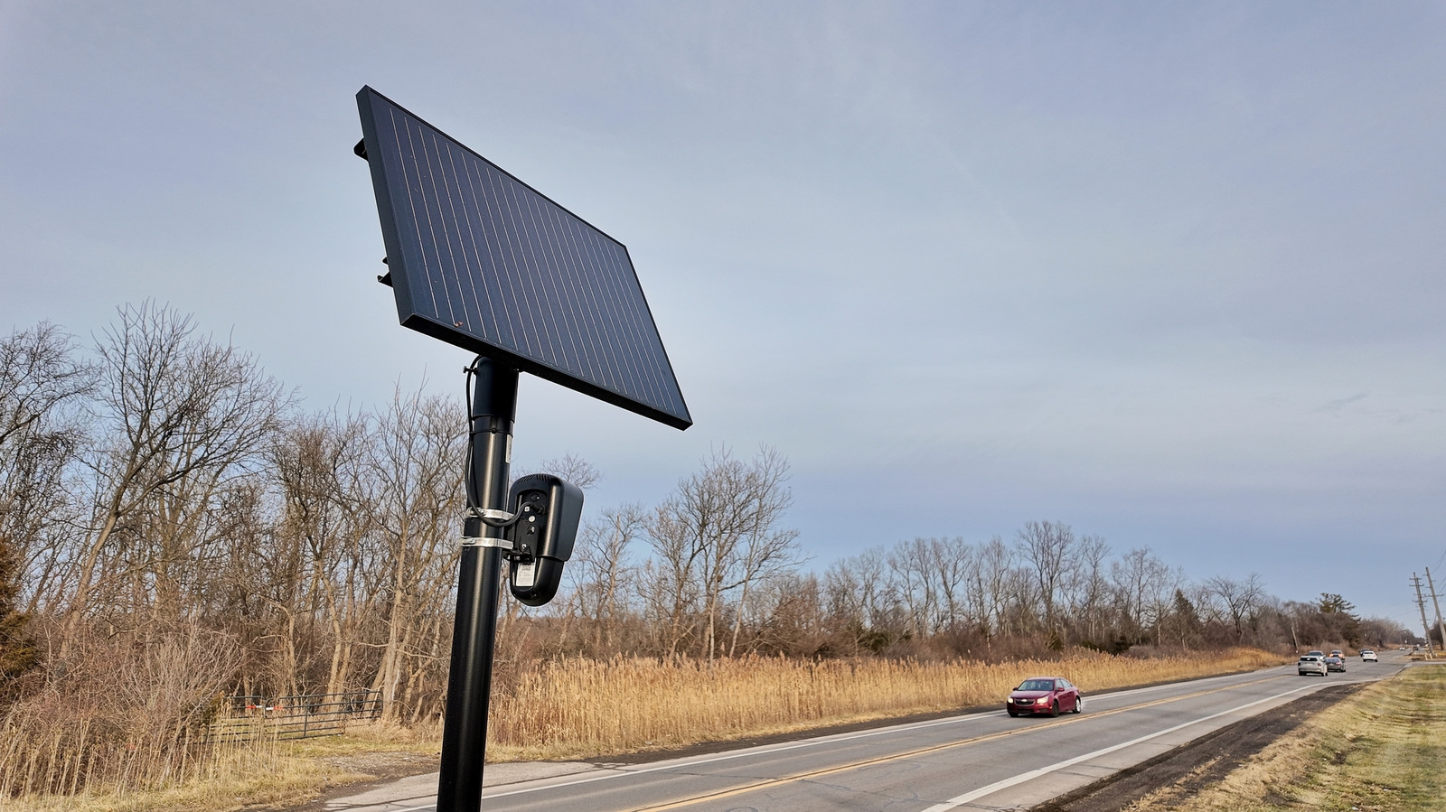
However, privacy advocates, including organizations like the American Civil Liberties Union (ACLU), argue that ubiquitous surveillance transforms public spaces into zones of constant monitoring, fundamentally altering the nature of public interaction. They contend that the collection of massive amounts of data on innocent citizens constitutes a form of mass surveillance that is disproportionate to the stated goals of crime prevention.
The "Chilling Effect" and Potential for Misuse
A significant concern is the "chilling effect" that pervasive surveillance can have on civil liberties. When individuals know they are being constantly monitored, it can subtly suppress their willingness to engage in lawful activities such as protests, political organizing, or even simply visiting places they might not wish to be publicly associated with. The fear of being tracked, profiled, or having one’s movements scrutinized can lead to self-censorship and a reduction in civic engagement.
Furthermore, the potential for misuse of surveillance data is a recurring worry. This includes the possibility of racial profiling, the tracking of activists or journalists, political targeting, or even simply the arbitrary use of data by law enforcement without a specific warrant or reasonable suspicion. Instances of LPR data being used to identify attendees at specific events or to track individuals without criminal intent have fueled these concerns. The lack of robust oversight mechanisms and clear legal frameworks for data retention, access, and usage exacerbate these fears.
Advocacy Group Stance
Civil liberties organizations consistently advocate for stricter regulations on surveillance technology. Their demands typically include:
- Transparency: Public disclosure of where cameras are located, who operates them, and what data is collected.
- Accountability: Clear audit trails for data access and usage, with severe penalties for misuse.
- Necessity and Proportionality: Requiring a demonstrated need for surveillance technology and ensuring that its use is proportionate to the threat.
- Data Retention Limits: Strict limits on how long data can be stored.
- Public Debate and Oversight: Mandating public hearings and democratic oversight before the deployment of new surveillance systems.
MapQuest’s new feature, by offering transparency, aligns with one of the key demands of these advocacy groups, empowering citizens with information that was previously difficult to obtain.
MapQuest’s Feature: A Tool for Transparency
MapQuest’s decision to integrate surveillance camera locations is a notable move in the digital mapping space, positioning the service not merely as a navigation tool but as a provider of critical contextual information for the modern urban environment. The company’s announcement of the update, accompanied by a short video set to Rockwell’s iconic "Somebody’s Watching Me," was a clever nod to the cultural implications of pervasive surveillance and resonated with public sentiment.
User Empowerment and Informed Decision-Making
The primary benefit of this new layer is user empowerment through transparency. While the article notes that users "might not be able to easily avoid these cameras on your commute or other usual routes," the value lies in illuminating the sheer pervasiveness of surveillance infrastructure. For individuals concerned about privacy, this information allows for a more informed understanding of their daily environment. It enables them to visualize the extent to which their movements are recorded and cataloged, fostering a heightened sense of awareness. This knowledge can contribute to more informed decisions about personal privacy, routes taken, and even participation in community discussions regarding surveillance.
Distinction from Evasion Tools
It is crucial to distinguish MapQuest’s new feature from tools explicitly designed for evasion. Unlike applications that might facilitate the circumvention of speed traps or traffic cameras for the purpose of avoiding penalties, MapQuest’s surveillance layer is presented as an informational tool. Its stated utility is to illustrate the omnipresence of cameras, which, as the article implies, are often unavoidable. The intent appears to be less about helping individuals actively dodge surveillance and more about providing a clear, visual representation of the surveillance footprint in their surroundings. This transparency can be a powerful catalyst for public discourse and local advocacy efforts.
The "Somebody’s Watching Me" Campaign
The choice of Rockwell’s "Somebody’s Watching Me" for the announcement video was a masterful stroke of marketing and messaging. The song’s lyrics perfectly encapsulate the widespread public unease surrounding surveillance, transforming a potentially dry feature announcement into a culturally resonant statement. It highlights MapQuest’s awareness of the public’s sentiments regarding privacy and surveillance, aligning the company with a stance of transparency and user advocacy. This creative approach garnered significant attention and contributed to the feature’s immediate impact.
Reactions and Implications
The introduction of MapQuest’s surveillance camera layer is likely to elicit varied reactions from different stakeholders and carries several broader implications for public discourse, policy, and the future of location services.
Perspective of Privacy Advocates
Privacy advocates are likely to welcome MapQuest’s initiative as a positive step towards greater transparency. By making the locations of surveillance cameras publicly accessible and easily viewable, MapQuest is effectively demystifying a hidden aspect of the built environment. This aligns with their long-standing calls for greater public awareness and disclosure regarding surveillance technologies. While the feature does not dismantle the surveillance infrastructure itself, it provides a crucial tool for communities and individuals to understand its scope, enabling more effective advocacy for regulation, oversight, or even the removal of cameras where deemed intrusive or unnecessary. It can serve as a data point for local activism and policy debates.
Potential Impact on Public Discourse and Policy
The visual representation of surveillance camera density offered by MapQuest could significantly impact public discourse. Seeing the multitude of cameras in one’s own neighborhood or along a daily commute might provoke a more visceral understanding of pervasive surveillance than abstract discussions or reports. This could galvanize community action, leading to increased pressure on local governments, law enforcement, and HOAs to justify the necessity of these cameras, implement stricter oversight, or reconsider their deployment. The tool could become a resource for investigative journalism, academic research, and grassroots movements aiming to map and challenge the expansion of surveillance. This newfound transparency could prompt a re-evaluation of current surveillance policies and practices at local, state, and even national levels.
Future of Location Services and Data Transparency
MapQuest’s move might signal a new frontier for location-based services. Beyond guiding users from point A to point B, mapping applications could evolve to provide more comprehensive contextual data about the environment, including elements that have significant social, political, or privacy implications. This could extend to mapping other types of sensors, environmental monitoring stations, or even public Wi-Fi hotspots, offering users a richer, more nuanced understanding of the spaces they inhabit.
The integration of such sensitive information also raises questions for other mapping giants. Will Google Maps or Apple Maps feel compelled to follow suit, or will they maintain their current focus, perhaps viewing surveillance mapping as too controversial or outside their core mission? MapQuest’s bold step could set a precedent, pushing the industry towards a greater emphasis on data transparency and user awareness regarding the unseen layers of the digital and physical world. It underscores a growing demand for tools that empower citizens in an age of ubiquitous data collection and monitoring.
Conclusion
MapQuest’s integration of surveillance camera locations into its mapping application represents a significant development, not only for the company itself but for the broader conversation around privacy, technology, and public transparency. Coming on the heels of a principled stand against geographical alteration and a series of practical feature upgrades, this move solidifies MapQuest’s image as a user-centric platform willing to address contemporary concerns. By illuminating the pervasive nature of LPRs and surveillance cameras, MapQuest empowers its users with valuable information, fostering a greater understanding of their environment and potentially fueling further public debate and advocacy for more robust oversight of these technologies. In an era where "somebody’s watching me" is less a paranoid fantasy and more a daily reality, MapQuest has provided a tool to make that reality visible, marking a critical step in the ongoing quest for digital and physical transparency.